
Fears of ‘deforestation rush’ in tropical rain forest if Brazilian congress passes bill to pave Amazon highway
[ad_1]
Fears of ‘deforestation rush’ in tropical rain forest if Brazilian congress passes bill to pave Amazon highway
The bill approved in the Lower House allows the use of mostly international funds, US$ 1,3bn for the “recovery, paving and increasing the capacity of the highway”. (Pic O Globo)
The lower house of Brazil’s Congress passed a bill that allows the paving of highway BR319, which crosses the heart of the Amazon basin and which scientists and environmentalists claim threatens the future of the world’s largest tropical rainforest. The bill still has to be approved by the Senate.
The basin spanning eight countries has been called the lungs of the Earth for its effective function of converting huge volumes of carbon dioxide into oxygen.
But the bill would also allow the use of mostly international funds for the “recovery, paving and increasing the capacity of the highway”. This means that capital such as the Amazon Fund’s US$1.3 billion — supported by European and United States allies to be used for conservation — could go toward the project.
“I don’t think it makes any sense. This project does not fit into any of the fund’s planned support lines,” Tasso Azevedo, one of the creators of the Amazon Fund admitted.
BR-319 was built in the early 1970s by the country’s then-military dictatorship, but quickly deteriorated, and by 1988 had become impassable. Preventing more access is one of the biggest defenses the Amazon has against deforestation. A new road opening up in the undisturbed rainforest provides a way in for loggers, farmers, miners and developers, who often conduct their activities illegally.
Since 1978, the Amazon has lost more than 185 million acres to deforestation, and the rate of destruction is accelerating, according to the Amazon Conservation website. Nearly all Amazon deforestation — 95% — happens within 3.4 miles of a roadway.
“Deforestation follows a fairly predictable pattern,” NASA Earth Observatory said, referring to satellite images on its website.
“The first clearings that appear in the forest are in a fishbone pattern, arrayed along the edges of roads. Over time, the fish-bones collapse into a mixture of forest remnants, cleared areas, and settlements. This pattern follows one of the most common deforestation trajectories in the Amazon.
”Legal and illegal roads penetrate a remote part of the forest, and small farmers migrate to the area. They claim land along the road and clear some of it for crops. Within a few years, heavy rains and erosion deplete the soil, and crop yields fall. Farmers then convert the degraded land to cattle pasture, and clear more forest for crops. Eventually the small land holders, having cleared much of their land, sell it or abandon it to large cattle holders, who consolidate the plots into large areas of pasture.”
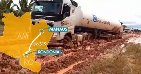
The old BR-319 highway — which has become a dirt road full of crater size potholes that is impassable five months of the year, during the rainy season — stretches approximately 900 kilometers from Rondonia state’s Porto Velho to Manaus in Amazonas.
Those defending the paving project say it is needed to connect Amazonas and Rondonia, as Manaus is frequently inaccessible except by air and river.
The bill to approve the paving of BR-319 refers to the highway as “critical infrastructure, indispensable to national security, requiring the guarantee of its fluid traffic”.
Amazon researchers say the repaved road would trigger an explosion of deforestation in Amazonas state, home to most of Brazil’s best-preserved rainforest state due to a lack of roads.
Every major highway project in the Amazon has set off a surge in land grabbing and illegal deforestation. Researchers say BR-319 would open a new frontier for logging that could push the rainforest past a point of no return.
[ad_2]
Source link


